Imagine your 12-year-old has wandered away from his Scout troop and is reported lost. Did he try to return to camp by heading through trees? Could he have climbed the rocky slope to the north to chase a squirrel? Or did he try to find the creek? You can only guess. As the hours pass, the temperature drops, and darkness closes in, you pray that, somehow, searchers will find him.
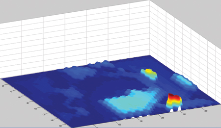
Lanny Lin (MS ’09), a PhD computer science student, created a statistical model that may help future search teams find lost hikers, or your Scout, more quickly. Beginning with where and when the lost person was last seen, the program would take four basic factors into consideration: the topography, vegetation, and elevation of the area as well as human-behavior patterns gathered from studying how hikers respond to similar terrain features while geocaching. Lin’s program would then generate a map showing regions where your Scout would most likely go so searchers or unmanned aerial vehicles (UAVs) can cover the most probable destinations first.
Computer science professor Michael A. Goodrich (BS ’92) mentored Lin’s research on the program, and the two have also collaborated on UAV research and other search-and-rescue work. Their findings have been featured in the academic journal Computational and Mathematical Organization Theory and the magazine Popular Science.
Lin is now refining the program so that it can be used in real searches. “[The program] can’t take over the job completely,” says Lin, “but it’s a tool that can show teams important places to look.”