1. Bonneville Shoreline Trail
The trail will one day run 280 miles from Idaho to Nephi, Utah.
Distance: 24 miles in the stretch from Provo Canyon to Hobble Creek Canyon in Springville, Utah
Difficulty: Easy
From BYU: Head east from BYU to the foothills to pick up the unmarked trail, which runs north and south.
2. Provo River Parkway
This paved trail passes several parks and Bridal Veil Falls.
Distance: 13 miles in the stretch from Utah Lake to Bridal Veil
Difficulty: Easy
From BYU: Pick up the trail at the intersection of University Avenue and 2230 North.
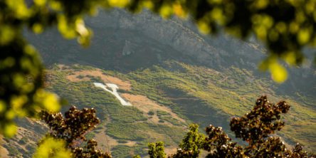
3. Y Mountain
No U.S. college has a letter larger than the Y on Y Mountain.
Distance: Roundtrip, 2.4 miles to the Y, 7.5 miles to the summit
Difficulty: Moderate
From BYU: From 900 East, turn east on 820 North. Turn right onto Oakcliff Drive, then right again onto Terrace Drive.
4. Squaw Peak Trail
The sharply projecting Squaw Peak offers panoramic views.
Distance: 6 miles roundtrip
Difficulty: Moderate
From BYU: From 900 East, turn east on North Temple Drive and follow it to the Rock Canyon trailhead. Fork north off the Rock Canyon trail at the Squaw Peak trail sign.
5. Slate Canyon to Slide Canyon
This less-traveled, thigh-busting trail wraps around Maple Mountain.
Distance: 8.4 miles roundtrip
Difficulty: Moderate
From BYU: Begin at the Y Mountain trailhead. Instead of taking the Y trail, take the Bonneville Shoreline Trail south. Fork left into Slate Canyon (canyon is not marked).


